Monday, May 9, 2022

North To Loreto

We stayed four days on El Quemado Beach around the headland from Puerto Escondido. We braved the submerged rocks twice a day to reach the sandy swimming area beyond, I walked Rusty who hid in the shade during the hottest hours when the sand burned his paws. 

Our plan was to drive north along Highway one to the small coastal town of Loreto 15 miles away on the Sea of Cortez. Once we’d done our shopping we’d carry on north up the only road available and look for a properly sandy beach. 

It was a strange desert drive up the coast. The highway was smooth and well marked, a common feature of driving in Baja we are discovering. And as we got close to town businesses appeared with signs in English and obviously catering to gabachos. Above we came upon Loreto Bay Inn, a golf resort worthy of Palm Springs or Scottsdale and here we are ostensibly in Mexico. 

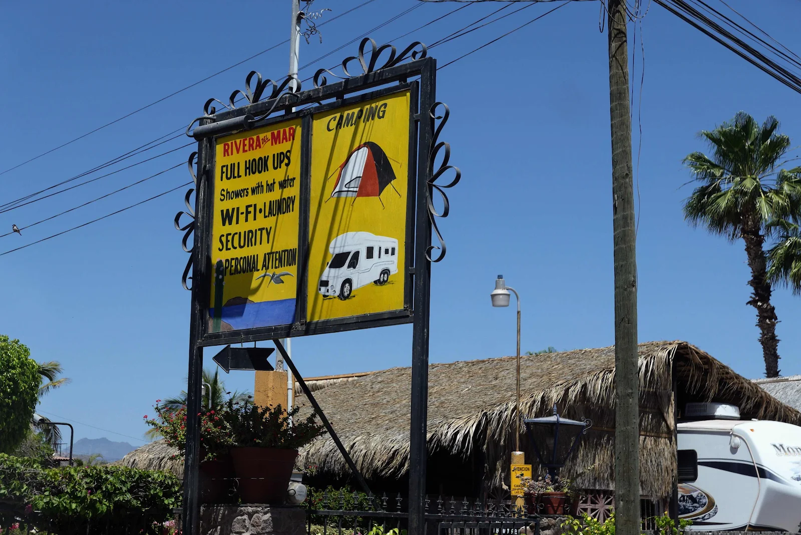
For lesser mortals the attention to detail is all in English. “Security” they promise as though outside the walls of the RV park it’s the Wild West. We promptly took our life in our hands and bought some sliced fruit from a guy on the street. 

Loreto is a pretty little beach town with clean streets and landscaping. If you don’t speak Spanish don’t worry. Half the population has spent time working in the US and no one here opens a conversation in Spanish with an obvious foreigner. 

We found this a little disconcerting and what was worse the Ley supermarket had a terrible fruit and vegetable selection. We’d seen the delivery trucks coming over on the ferry, dozens of the Ley’s trailers and time didn’t in transit doesn’t do produce any good. Layne was grumbling about missing the fruit stands of the mainland. I was forced to pinto it Baja is a desert and they don’t grow anything to sell in the southern half of the peninsula. 

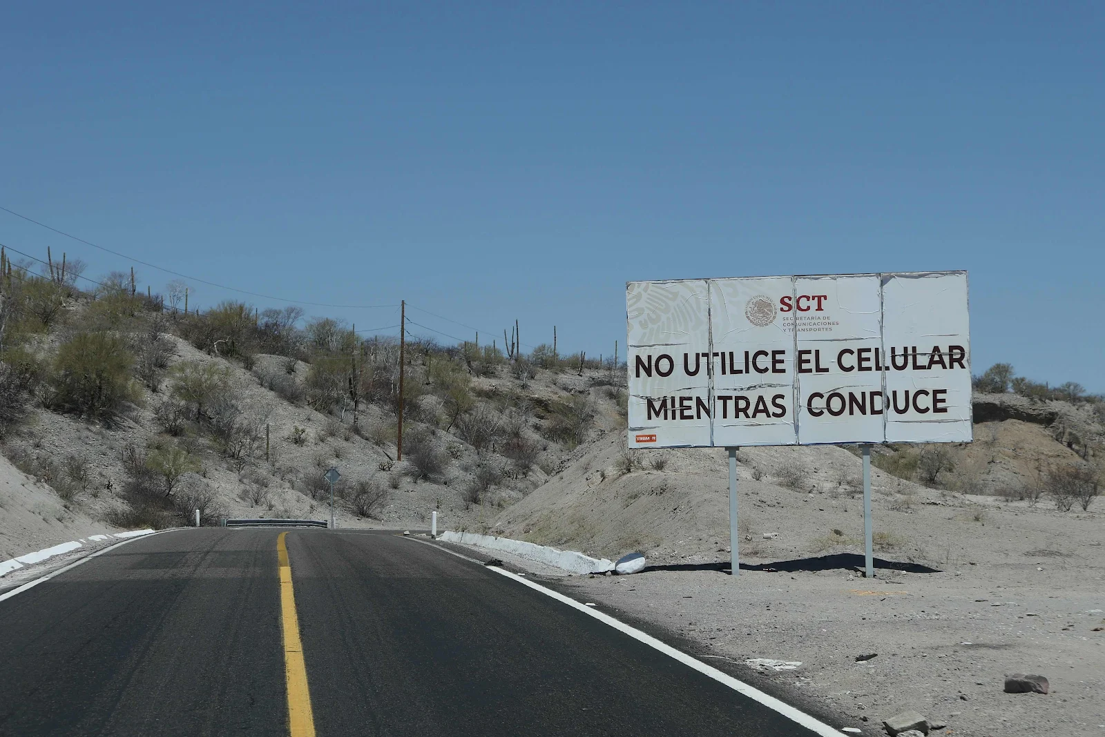
We had our roast chicken for dinner and we picked up some tortilla rolls filled with a meat and potato mixture when we bought some fresh flour tortillas. With that and the fruit slices we had lunch. Cook’s day off! We took to the road again heading north, the only way out of town for us. I liked the sign warning not to use the cellphone while driving. There wasn’t a hint of a signal anyway so the warning was pointless. I took the picture using my pocket camera which I keep for those occasions. 

North of Loreto the highway cuts inland for a couple of dozen miles and it’s all desert, some of it quite spectacular. 

And then we came to a military checkpoint where the cars that had passed us on the curves were now waiting for one of their number to get his body cavities inspected by a serious military check. My heart sank. 

The dude from Washington State in front of us on the Triumph tourer got waved through and he paid a visit to the useful sanitarios, a civilized touch in this desert inferno. We got to the front of the line eventually and faced two questions: Where are you coming from? -Loreto. And then: Where are you going to? -MulegĂ©. Pass friend. Not so tough!   

The road took off into the desert driving by colored rock formations and dry river beds, winding around hillsides covered in saguaro cactus and thorn bushes. Occasionally there was a house often turned into a modest truck stop to feed passing drivers but mostly the whole place was empty, as a desert should be. The air temperature measured 96 on the dashboard. 

It’s illogical but as we came through the pass and started our descent to Bahia Concepcion I expected to see signs of life, beaches, stopping places. I had no evidence for such things. 

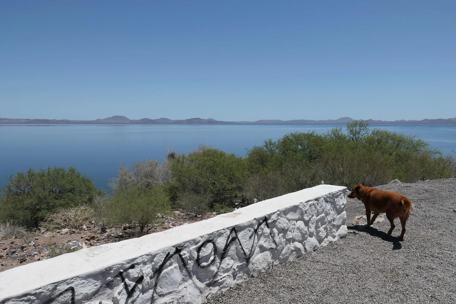
As we passed the monument marking the beginning of the MulegĂ© municipal district and the end of Loreto we pulled over to check the scenery. And the smells 

Our plan, such as it was, consisted of finding a sandy beach, no rocks, and room to park. Pretty simple. The iOverlander app showed very little that might meet our modest needs. There were rocky beaches everywhere, some isolated and free and others with modest fees. But sandy swimming beaches seemed out of reach. We were surprised. 

And then we saw Playa Armenta, far nicer than described on the iOverlander app and just right for us. There were two entrance tracks with one approschbsteep rocky and short while the other was longer but sandy and easier. That was the one for us. 


Better believe we paid for the shade. And loved it. 


The swimming was excellent and the salt water was warm. The pit toilets were not a problem as we used our porta potty and I emptied that into the toilets that were not enthusiastically described on the app. 

We had no cell service at all and there was nothing around the beach, no restaurants or shops or even a water faucet. It as waterfront wilderness and best of all Rusty was happy. We settled in. 

Sunday, May 8, 2022

The Hart Trail


Baja is a desert so nights tend to cool down considerably and I thoroughly enjoy snuggling into our van bedding, expensive soft cotton sheets inside a double cotton cocoon, thicker on the winter side and thinner on the summer side. A sleeping bag for comfort seeking adults. I sleep well protected from the cold desert air. Rusty starts stirring from his huge comfortable bed on the floor. He yawns loudly.

It’s time for us to walk and it’s only 6:30. A truck camper is up a couple of spots. By the time we walk back it’s gone. 

The sun comes up slowly of course and we can pick our way through the thorn bushes before the day gets hot. 

It’s hard to explain how massive and imposing the mountains are hovering on the western horizon. They cut the coastline off from the rest of peninsula and Highway One wiggles over the pass to get down to Loreto. In Mexico it’s just another cliff. 

There are trails winding through the bushes but there is one trail I want to walk before the day heats up. It’s called the Hart Trail and it goes sharply uphill. 

Apparently it’s become the Hart Memorial Trail as the person it was named for has since died. His death date is written in the Canadian style (rest of the world style) reversing the month and day method used only in the United States. I am forced to assume Craig was a Canadian lacking Internet service to investigate further. 


At first Rusty is not keen but I am plodding up with or without him. He gets the idea and scrambles easily ahead of me. 

The trail is steep but starts as a dirt path lined with stones but when the trail takes a sharp turn uphill there is less path and more scramble. 

Rusty is out of sight but I keep plodding doggedly determined to not hurt myself. Occasional glances over my shoulder reveals much beauty below. 

For Rusty it’s a case of hurry up and wait. He’s enjoying the scramble. 

For me it’s a steady walk on the level bits and careful foot placement on the uphills. 

There are occasional markers indicating organized trails hither and yon making me feel momentarily as though we’re on a US park trail, and Rusty off leash no less! Actually distances are in meters so it must be Canadian…

I felt like we were keeping pace with the sun as we rose higher and higher. 

In the photo above we are parked along the curve of beach before the first small point that sticks out. Lost in the shrubbery. Below looking east  across the bay. 

My plan is to reach the top of smaller pimple. My to my discomfort the trail winds back and forth, a jumble of rocks going vertical. Trip here and you will launch yourself into space I tell myself thinking of the pins holding my legs to my already shattered pelvis. 

Rusty is trotting back and forth like a mountain goat, below me and above me on his own weird schedule. I focus on putting my feet down securely between wobbly rocks while trying not to look over the edge at the chasm that tumbles down to the water’s edge. Coming down may be tricky I reassure myself. 

I have summit fever, determined to reach the top of the hill. I take my picture uncomfortably wondering if this will be another of those pre-accident photos I have come to be known for. On a happier note the scenery is splendid. The development: 

The anchorage:

Our private beach below with a newly arrived waterborne neighbor anchored close by our spot. 

The mountains to the west of us. 

Rusty rested with me as I discovered a cell phone signal. Not enough to post a full essay on my blog so I wrote a quick paragraph explaining our straitened Internet circumstances, add a picture and manage to post that small explanation of my internet silence.

I send Webb a quick note to reassure him I’m alive as though he had any doubt; I send some texts to friends for the same purpose, and Bruce reassures me my new camera is waiting for me at his home in Arizona. Then I update my crossword page. Odd our priorities with fifteen minutes of weak internet access available! 

With dread in my heart I leave Mount Everest and face the ghastly vertical scramble down the demoralized rock pile. It’s actually not as bad as I think and I allow my mind to wander to the real Everest, the one where George Mallory and Sandy Irvine disappeared in 1924. Mallory was found in 1999 recognizably intact where he fell and died but Irvine his younger companion has disappeared And with him the camera that might have proved they made it to the top, the first to so do. 

Rusty sits waiting for me at a junction. It’s embarrassing how fast my buddy runs downhill but he always keeps an eye on my progress and waits before getting too far ahead. He’s reassuring.

I’ve read a new rumor that has finally been made public about Sandy Irvine’s body which was reportedly seen on the mountain by a Chinese climber decades ago. Just as another Chinese climber came across Mallory’s body long before the Americans located him and made the public announcement. It seems the speculation  is that the Chinese may have removed Irvines body and stored it in Nepal to preserve their own claim to be the first to summit Everest in 1960. If Irvine’s camera shows the two Englishmen on the summit in 1924 that would blow the gaffe for all others in their pursuit of glory. Mountains do strange things to people. 

I was quite happy to get to sea level after two hours walking. We had a second sailboat anchored this time right in front of us. I hope he didn’t mind me showering naked as I had a lot of dust to wash off and he had lots of other places along the beach to anchor if it mattered to him. It was a good walk for both of us. 

Saturday, May 7, 2022

Playa El Quemado

We spent one evening chatting with Cheryl and Guy, travel stories about sailing from us and stories of fixing their truck in exotic places from Cheryl. Guy went bird watching while we tried to disabuse his wife from seeking it out travel by sailboat. Few sailors sail, ask Webb Chiles, but many use their boats like watery vans chugging from beach to beach. I have always loved driving and ever since I dropped the emotional appeal of being a pirate I find my travels more stimulating. As Webb puts it “vive la difference.”  

The occupants of the large RV make themselves thoroughly disagreeable announcing the firewood none of us was interested in was THEIRS and they stormed back to their palazzo with their wood. Guy collected some more wood and added it to their pile. They walked their dog looking away from us the intruders. In Mexico the nastiest people you can meet might be the foreigners. Very disappointing were these gringos. We all left in the morning and said goodbye to the lovely Aussies, eleven years on the road. 

We were on our own and I had scoped out the neighboring beach on foot. It looked perfect, so waving goodbye to the Australians we drove  around the hill to check out Puerto Escondido, a long time sailboat anchorage in a hidden (“Escondido”) bay. Nowadays it’s a development with restaurant store and gas pump. We did a quick drive by repelled by the feeling of Marina Del Rey South. 

iOverlander, the traveler’s app is fed by reviews and reports called “check ins” from users of the app. Our check ins are listed under our name thegoldenvan.com because we try to contribute not just use. We read the instructions on how to reach El Quemado Beach and as we departed the wide paved avenues of the development under slow progress we looked left and saw the dirt road that had to be the unmarked way to the wild camp beach. 

The dirt track passes through a check point apparently created by the Federal tourist development authority called Fonatur. The yellow trailer was so labeled and iOverlander reports they charge a five dollar fee in high season. Not now they don’t. We paid no fee and had no services, packing our trash, the most basic service van travelers require. 

A sign! Not strictly necessary but a nice effort to make us feel civilized, not wild campers. Layne and I figured later, as we swam, that winter residents get all sorts of enterprising services, delivery of water, bread or tamales and what not. We see no one in early May. Everyone has gone home. More or less: 

The road is ten minutes long but shows signs of grading probably fine to welcome winter residents. 

The water at this beach is quite cold. The curve of sandy beach is lined underwater by irritating ankle breaking slippery boulders making it an awkward walk to deeper waters. It’s a lovely spot ashore and we drove slowly among the thorn bushes looking for the beach front camp that suits us. 

We find a break in the bushes marked with a number 14 as this is formalized wild camping. We set up camp, Moonshade for our awning, a sand blanket for a door mat, a solar shower to wash with and chairs to lounge, a collapsing table to play backgammon and eat. Then we struggle through the rocks for a swim. 

It’s a pretty spot surrounded by huge sheer mountains jagged and impenetrable. Across the water uninhabited desert islands which hide the sunrise. 

Dolphins swim by in endless pods. 

Layne spares her ankles and gets out of the water in one piece, ready to cook, a pastime she enjoys. For simplicity we cook on electricity and have no propane to avoid dealing with foreign fixtures which plagued us on the boat 24 years ago. 

A kitchen with a view: 

This spot will be our home for four days. Isolated and largely alone, no contact with the outside world. Which suits us for the moment.